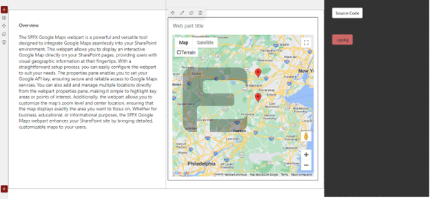
The Fusepoint Google Maps webpart integrates interactive Google Maps directly into SharePoint pages. This solution provides visual geographic information with customizable locations, zoom controls, and API key configuration for secure access to mapping services.
Features
Interactive Maps: Fully functional Google Maps embedded in SharePoint
API Key Management: Secure configuration of Google Maps API access
Location Management: Add and display multiple points of interest
View Customization: Adjust zoom levels and center position
Responsive Design: Works across all devices and screen sizes
Choose FusePoint Google Maps from the web part gallery
Position the map where desired on your page
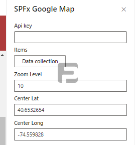
Configuring the Map
Enter your Google Maps API key in web part properties
Set default zoom level and center location
Add locations with addresses or coordinates
Save to display the configured map
Managing Locations
Add new points of interest through properties
Edit existing locations as needed
Remove outdated or irrelevant markers
Customization Options
Map Style: Choose between different map views (roadmap, satellite, etc.)
Marker Design: Customize location pin appearance
Zoom Controls: Set default and allowed zoom ranges
Interactive Elements: Enable/disable user controls like panning and zooming
Benefits
Enhanced Visualization: Brings geographic data to life
Centralized Information: Displays multiple locations in one view
Easy Maintenance: Simple location updates through properties
Secure Integration: Proper API key management
Universal Access: Works on all modern devices
Conclusion
The FusePoint Google Maps web part transforms SharePoint into a powerful mapping platform, enabling organizations to visualize location data effectively. With its combination of customization options and ease of use, it provides valuable geographic context to any SharePoint site.
Try FusePoint for Free!
No credit card required.
FusePoint
The perfect addition to your SharePoint environments.